Port Strategy —
by John Bensalhia
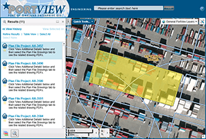
 Throughout history, variations of Geographic Information Systems (GIS) have been devised. A prototype was assembled by physician John Snow in 1854 to deal with the source of a cholera outbreak in London. In 1960, the first bonafide example was developed by geographer Dr Roger Tomlinson in order to store, analyse and use information gathered for the Canada Land Inventory. Today, GIS has progressed immeasurably, thanks to technological advances. With sophisticated technology and data facilities, GIS is invaluable for ports. As Graham Wallace, senior business strategist for Esri UK says, GIS provides “one single view of the truth”.
“Data collected from diverse in-house and external systems in a non-visual format can be presented in a readily usable, visible format ie: on a map. Map-based information can then be interrogated to understand why there are variances in a specific location, adding an extra dimension to data management and analysis.”
Daniel Elroi, president of NorthSouth GIS LLC, identifies vital performance capabilities. “GIS is a critical tool for helping ports to increase revenues by identifying under-performing real estate and helping to attract new tenants; reduce costs from time lost in searching maintenance costs of assets and correlating them to the rent rolls and general ledger, or time and accuracy lost from the re-entry of field inspection notes back in the office; and to increase return on investment from engineering projects by integrating project data back into the overall base maps of ports…”

 Enesgy